Where in Maryland (and Virginia)?
- History Revealed

- Feb 24, 2020
- 4 min read
When we think about ledgers, the first thing we wonder about are all the items sold by the store. Then, we wonder who all the shoppers were and where they came from to shop in the store. But, what about the store's connections to the greater world? In today's #TranscriptionTuesday post, we need help figuring out what and where some of the places mentioned in the Jenifer & Hooe (1775-1777) Alexandria store's "Crop Tobacco" account were.
By the fourth quarter of the 18th century, many farmers along the Chesapeake Bay of Virginia and Maryland had shifted away from tobacco as their primary crop to other less profitable, but more sustainable options, like wheat and corn.[1] Yet, we still find tobacco moving through the local stores. The "Crop Tobacco" account at the Jenifer & Hooe Alexandria (1775/1777) store indicates the store operated in small amounts of tobacco well after the start of the American Revolution. (The store also had individual accounts for: bar iron, beans, beef, beeswax, bread, flaxseed, flour, Indian corn, lumber, peas, plank, pork, rye, salt, stone, and wheat.)
During the period of the ledger, the store moved 692 hogsheads of tobacco, spending £9194..17..6 ¾ in support of the Crop Tobacco account, with the bulk of the hogsheads and monies accruing during the period of February to August, 1777.[2] Sometime in 1776, the store developed a much stronger relationship with farmers in Maryland and began to purchase tobacco from them, likely due to the agricultural shift by Virginia farmers to other crops.

Our focus in today's post though is on all those places from whence the store acquired its tobacco, especially places in Maryland, and where the warehouses were located. Tobacco warehouses established by inspection acts in Virginia (1730) and Maryland (1747) maintained the quality control over tobacco exported from the region, requiring the store to go to those specific warehouses to pick up hogsheads exchanged by customers for goods and services provided by, for, through, or on behalf of the store.[3]

We have been able to successfully identify the probable locations of several of the warehouses based on present day town names: Colchester, Dumfries, and Boyds Hole in Virginia, and Piscataway, Pomonkey, Chicamuxen, Nanjemoy, and Port Tobacco in Maryland. However, we have three locations in Maryland and one in Virginia where we need help placing flags on our map.
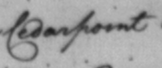
In Virginia, the store identified Potomac Creek as a place tobacco was retrieved. We know where Potomac Creek is today, but where was the tobacco warehouse found in Stafford County then? In Maryland, we identified Cedarpoint, Levelling, and what looks to be "Piles", in which we are uncertain where they were in the 18th century.
Both acts, and their associated revisions, provide some assistance with geography, but they used land owners which we have yet to be able to identify on a map and hope you can help.
"In Charles County, ...at Piles's Fresh, on Mrs. Jane Parnham's Land, at the Head of Wiccocomico River, under one Inspection; at Lower Cedar-Point, on Charles Jones's Land, under one Inspection..." at least point us to the possible locations of Piles and Cedar Point.[4]
Another clue to location in regards to the cost of freight (noted) for moving the hogsheads may also help, as found from least to most:
Pomonkey: 4 shillings 3 pence
Colchester: 4 shillings 6 pence
Dumfries: 5 shillings
Chicamuxen: 5 shillings
Boyds Hole: 6 shillings
Nanjemoy: 6 shillings
Cedar Point: 7 shillings
Port Tobacco: 7 shillings 6 pence
Levelling: 8 shillings 6 pence
Piles: 10 shillings
If we return to the map and consider distance and accessibility from Alexandria, the freight charges seem logical and progress down the Potomac River - meaning the location of Cedar Point must be between Boyds Hole and Port Tobacco based freight costing 7 shillings, and of Levelling and Piles must be either farther down the Potomac River OR located farther inland given their costs of 8 shillings 6 pence and 10 shillings, respectively.

Being able to identify these places on a map allows us to see the geographical connections and influence of not only the single store in Alexandria, but also the community writ large. We can begin to explore how the Potomac River enhanced trade between Virginia and Maryland; and how it supported an inter-colonial relationship between farmers, merchants, watermen, and other tradesmen (and women). If you can help us place any of these locations on our map, please let us know!
[1] Salmon, Emily Jones and John Salmon. "Tobacco in Colonial Virginia." Encyclopedia Virginia. Virginia Humanities, 29 Jan. 2013. Web. 20 Feb. 2020.
[2] Folio 249, "Crop Tobacco" account, Jenifer & Hooe Alexandria Store, 1775/1777. This folio represents only the period between February and July 1777, the most geographically active over the three years included in this ledger. At the beginning of this folio, the store had only moved 56 hogsheads and £610..4..3 ½. Folio 110 covers May 1775 - May 1776 and shows a relationship primarily with Virginia tobacco through the warehouse at Hunting Creek. Folio 185 covers August 1776 - February 1777 and shows a shift to Maryland tobacco from Pomonkey and Port Tobacco.
[3] Hening's Statutes at Large. "The Virginia Tobacco Inspection Act (1730)." 24 Feb. 2020; Proceedings and Acts of the General Assembly, 1745-1747. "The Maryland Tobacco Inspection Act (1747)." Maryland State Archives. Web. 24 Feb. 2020.
[4] Proceedings and Acts of the General Assembly, 1745-1747. "The Maryland Tobacco Inspection Act (1747): Places for Inspecting Houses In." Maryland State Archives. Web. 24 Feb. 2020.


Comments